Natural Catastrophe Modeling in Insurance – A Complete Guide

Driven by rising climate volatility and a surge in billion-dollar disasters, traditional actuarial methods are no longer enough to protect the insurance industry. Natural Catastrophe (NatCat) Modeling has emerged as a vital predictive framework that combines climate science, geospatial data, and advanced AI to simulate complex disaster scenarios. By transitioning from historical data to real-time, forward-looking risk intelligence, NatCat modeling empowers modern insurers to price premiums accurately, manage risk accumulation, and build long-term financial resilience against an increasingly unpredictable planet.
What Is Natural Catastrophe Modeling in Insurance (NatCat)?
Climate change is making natural disasters more frequent, severe, and costly. In California, wildfire risk has driven an 84% increase in home insurance costs over the past five years, while floods, the most common and costliest natural disaster in the U.S., caused more than $8 billion in damage in 2024, including $3.8 billion in areas not classified as high risk. Looking ahead, Fathom’s U.S. Flood Risk Index (2026) estimates that average annual flood exposure across the U.S. will increase by 72.6% by 2050 compared to 2020 levels.
As traditional actuarial models based on historical data become less reliable, insurers need more advanced approaches to assess evolving risks. Natural Catastrophe Modeling (NatCat) combines climate science, geospatial data, AI, and predictive analytics to simulate disaster scenarios, improve underwriting, optimize reinsurance, and strengthen risk and capital management.
Understanding Natural Catastrophe Modelling
What Is Natural Catastrophe Modeling?
At its core, Natural Catastrophe (NatCat) modelling is a predictive risk framework that helps insurers assess the financial impact of natural disasters. By combining climate science, geospatial intelligence, historical loss data, engineering insights, and AI, it simulates thousands of potential disaster scenarios to estimate portfolio losses. Unlike weather forecasting, which predicts where and when an event may occur, NatCat modelling translates hazard data into financial outcomes such as property damage, claims exposure, and insured losses. This enables insurers to improve underwriting, optimize reinsurance, strengthen capital planning, and make more informed risk decisions in an increasingly volatile climate.
What Is NatCat Modelling in Insurance?
In the insurance industry, Natural Catastrophe (NatCat) modelling acts as an essential diagnostic radar. Instead of crossing their fingers and waiting for a crisis to unfold, insurers and reinsurers use these models to actively simulate, evaluate, and manage the financial impact of environmental threats from sudden coastal storm surges to sweeping wildfires. It allows carriers to transition away from static spreadsheets and manual oversight, looking deep into their portfolios to see where the real vulnerabilities hide before a catastrophic event ever breaks ground.
Because weather disruptions don’t exist in a vacuum, NatCat models have become central to nearly every major function within an insurance operation:
-
Smarter Underwriting:
It completely redefines the underwriting workspace, moving teams past basic document processing to become true “decision architects.” Underwriters get property-level and regional exposure insights summarized in minutes, helping them quickly determine which risks are acceptable, which need stricter terms, and which should be avoided altogether. Quantiphi’s Climate Risk Simulation model improved underwriting accuracy by 30%
-
Portfolio Management:
It acts as a universal dashboard across an entire business. It tracks asset accumulation and flags regional “error hotspots,” allowing companies to actively monitor risk concentration across diverse geographies.
-
Dynamic Pricing:
Instead of relying on rigid, one-size-fits-all underwriting rules, it allows carriers to develop risk-based pricing. Premiums are dynamically aligned with actual local hazard probabilities and evolving climate variables, creating a fairer, more accurate pricing baseline.
-
Solvency & Capital Planning:
By stress-testing rare “tail events,” the software calculates expected loss curves. This gives executives the exact reporting visibility they need to safeguard capital reserves, satisfy auditors, and keep up with changing regulatory compliance standards.
-
Reinsurance Strategy:
It unifies chaotic broker spreadsheets and complex bordereaux data. This helps insurers accurately gauge their absolute financial threshold, structure balanced treaties, and buy the right amount of catastrophe coverage before the storm season kicks off.
Why Insurance Depends on Catastrophe Models
The insurance industry depends on catastrophe models because natural disasters are high-severity, low-frequency events that can cause massive financial losses. As climate risks evolve, historical claims data alone is no longer sufficient to predict future exposures, making forward-looking risk models essential.
This widening risk gap is reflected in several industry trends:
- $100B+ Losses Are the New Normal: According to Aon, global economic losses reached $260 billion, while insured losses totaled $127 billion, marking the sixth consecutive year catastrophe payouts exceeded $100 billion.
- Secondary Perils Dominate: Swiss Re reports that secondary perils including severe convective storms, flash floods, and wildfires accounted for 92% of global insured losses, highlighting the limits of traditional catastrophe models.
- Severe Storms Surpass Hurricanes: Aon and Allianz Commercial found that severe convective storms have overtaken tropical cyclones as the costliest insured peril, generating over $61 billion in insured losses in a single year.
- Historical Data Is No Longer Enough: Climate variability has reduced the predictive value of historical loss records. Insurers increasingly rely on AI-powered, forward-looking NatCat models to improve underwriting, pricing, and capital resilience.
By shifting focus toward these forward-looking, AI-driven scenario analytics, modern catastrophe platforms give companies a much clearer view of their true systemic exposure. Most importantly, it catches “accumulation risk” the silent danger where hundreds of separately insured properties are sitting in the exact same flood or wildfire path without the underwriter realizing it. Armed with that foresight, insurers no longer have to guess where the lightning will strike; they can confidently diversify their books, allocate capital where it matters most, and maintain rock-solid financial resilience for the long haul.
Evolution of Catastrophe Modelling
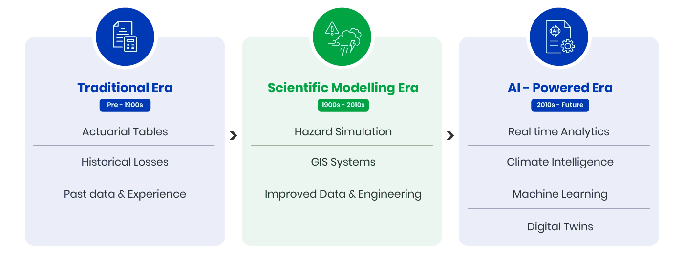
Catastrophe modelling has evolved from basic historical analysis to advanced AI-driven risk intelligence as climate risks and disaster complexity continue to increase.
-
Traditional Era:
Early catastrophe models relied on actuarial tables and historical loss data to estimate disaster risk based on past events and claims patterns.
-
Scientific Modelling Era:
With advancements in climate science and computing, insurers adopted hazard simulation models, engineering analysis, and GIS systems to better assess geographic exposure and disaster impact.
-
AI-Powered Era:
Modern NatCat modelling uses AI, machine learning, real-time analytics, climate intelligence, and digital twins to improve risk prediction, exposure monitoring, and catastrophe scenario simulation.
Need for Catastrophe Modelling in 2026
Rising Climate Volatility
Climate volatility is increasing the frequency, severity, and unpredictability of natural disasters worldwide, making catastrophe modelling more critical than ever for insurers and reinsurers. Climate volatility is increasing the frequency, severity, and unpredictability of natural disasters, making catastrophe modelling more critical than ever for insurers and reinsurers. Despite rising risks, insurance coverage remains alarmingly low.
According to FEMA data, fewer than 23% of homeowners in Louisiana, the state where flood risk is projected to rise the fastest, carry flood insurance. Coverage is even lower in Florida (under 15%) and in South Carolina and Texas (under 7%). Meanwhile, Fathom projects that 97% of the U.S. population will be exposed to flood risk by 2050, highlighting a widening protection gap. As climate risks evolve faster than historical loss patterns can predict, catastrophe modelling enables insurers to quantify future exposures, improve underwriting accuracy, optimize reinsurance, and strengthen portfolio resilience.
The baseline of major environmental perils has fundamentally shifted:
-
More Destructive Hurricanes:
Tropical storms and cyclones are rapidly intensifying over warming waters, causing catastrophic property damage, collapsing local infrastructure, and leaving a trail of historic insured losses across coastal regions.
-
Unprecedented Flooding:
It is no longer just about coastal storm surges; extreme rainfall events are triggering severe flash floods, overflowing rivers, and drowning urban centers that lack the drainage infrastructure to cope with sudden downpours.
-
Escalating Wildfires:
Rising temperatures and prolonged dry seasons have elongated the traditional fire calendar, fueling massive, fast-moving wildfire outbreaks that threaten expanding suburban borders.
-
Severe Heatwaves:
Extended spikes in temperature are placing immense strain on public infrastructure, agricultural yields, and energy grids, while quietly driving up health-related insurance claims.
-
The Rise of Secondary Perils:
Perhaps the most notable shift is that “secondary perils” like localized hailstorms, severe thunderstorms, flash floods, and convective storms are no longer minor footnotes. Today, these frequent, highly intense events are driving a dominant and rapidly growing share of global catastrophe losses, proving that localized volatility can damage a portfolio just as heavily as a single major hurricane.
Economic Impact of Natural Disasters
The ripple effects of major environmental disruptions hit modern organizations with massive operational and financial force. When a severe peril strikes, it touches every level of our global infrastructure, leaving a complex trail of challenges in its wake:
-
Insured vs. Uninsured Losses:
Catastrophic events generate massive financial waves. However, a significant portion of real-world destruction remains completely uninsured, widening the global protection gap and shifting heavy recovery burdens onto communities and businesses.
-
Systemic Economic Disruption:
Beyond immediate property damage, natural disasters can instantly paralyze local and regional economies. They fracture vital transportation networks, collapse power grids, disable communication channels, and force prolonged commercial shutdowns.
-
Supply Chain Risks:
Modern logistics networks are highly interconnected, meaning a localized hazard—such as a coastal flood or a severe wildfire—can cause global supply chain bottlenecks. These disruptions delay manufacturing pipelines, freeze inventory movement, and test the structural business continuity of multiple industries simultaneously.
Regulatory & ESG Pressure
In today’s market, corporate governance and financial compliance are inextricably tied to environmental awareness. Regulatory bodies and investment committees are placing strict expectations on how carriers manage climate vulnerabilities, transforming risk assessment into a primary transparency metric:
-
Mandatory Climate Disclosures:
Investors and financial regulators are moving past voluntary tracking to require detailed, transparent climate risk disclosures. Organizations must now explicitly report their exact exposure thresholds, carbon vulnerabilities, and long-term climate resilience strategies.
-
Tighter Solvency Regulations:
Regulators are continuously strengthening solvency requirements. Insurers are expected to maintain robust capital buffers that can withstand severe, low-frequency disaster events without threatening long-term solvency.
-
Adapting to Global Frameworks:
Compliance under frameworks like IFRS and Solvency II demands rigorous risk quantification and structural scenario auditing. Carriers must actively demonstrate that their capital adequacy reporting matches modern risk realities.
-
Rigorous Climate Stress Testing:
Insurers rely on advanced catastrophe frameworks to perform routine stress tests. These simulations assess how rare “tail-risk” scenarios would impact portfolio liquidity, asset valuations, and general market stability over time.
Why Historical Data Alone No Longer Works for Traditional Catastrophe Modelling
For decades, traditional actuarial teams operated under the assumption that the past was a reliable map for the future. However, rapidly accelerating environmental shifts have broken those long-standing statistical patterns, leaving static models unable to keep pace with contemporary climate exposure:
-
Non-Stationary Climate Risks:
The environmental baseline is no longer stable or predictable over multi-decade cycles. Rising global temperatures and shifting micro-climates are continuously altering hazard behavior, creating highly volatile risk dynamics.
-
Unpredictable Weather Fluctuations:
Major environmental perils are showing up in unexpected regions with unprecedented severity. Historic tracking spreadsheets simply cannot forecast where the next anomaly will hit or how intensely it will manifest.
-
The Fatal Flaw of Static Models:
Relying exclusively on backward-looking data leaves an organization blind to newly emerging secondary perils, cascading infrastructure failures, and forward-looking disaster scenarios. Modern NatCat modelling addresses this by blending live climate intelligence, geospatial tracking, and predictive analytics to deliver realistic forecasting accuracy.
How Natural Catastrophe Modelling Works
Natural Catastrophe Modelling (NatCat Modelling) combines climate science, geospatial intelligence, actuarial science, AI, and financial analytics into a multi-stage risk simulation process. It uses probabilistic analysis, hazard data, exposure mapping, and vulnerability assessments to simulate potential disaster scenarios and estimate financial losses.
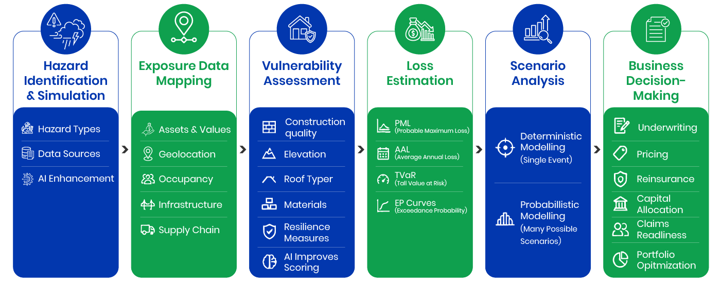
By modeling thousands of possible events, insurers and reinsurers can better assess risk exposure, improve underwriting, optimize reinsurance strategies, and strengthen capital planning against catastrophic events.
Step 1: Hazard Identification & Simulation
The first step focuses on defining the exact nature of the physical threat itself. Specialized engines simulate how specific environmental perils will develop, map their geographical trajectory, and calculate their potential severity.
Hazard Types
Modern NatCat platforms analyze a wide array of severe perils across distinct terrains:
-
Floods:
Tracking river overflows, coastal storm surges, extreme precipitation events, and sudden urban flash flooding.
-
Earthquakes:
Simulating tectonic ground shaking, structural fault ruptures, and the complex damages caused by seismic aftershocks.
-
Cyclones:
Modeling hurricanes, typhoons, and tropical storms to measure wind velocity, structural impact, and heavy rainfall boundaries.
-
Wildfires:
Mapping out large-scale fire paths influenced by regional droughts, seasonal high winds, fuel vegetation, and terrain elevation.
-
Hailstorms:
Capturing the unpredictable localized footprints of severe convective storms that produce damaging hailstones.
-
Tsunamis:
Simulating underwater seismic shifts or volcanic activities that displace massive oceanic wave systems toward vulnerable shores.
Climate Central reports that the U.S. experienced 23 billion-dollar disasters in 2025, causing $115 billion in damages and 276 deaths. The Los Angeles wildfires were the costliest event, underscoring the growing impact of climate-driven extreme weather.
Data Sources
To ensure high accuracy, these simulations ingest massive, multi-channel datasets:
-
Satellite Imagery:
Delivering granular overhead data, terrain changes, vegetation densities, and real-time storm tracking.
-
Meteorological Streams:
Feeding live atmospheric pressure, localized wind velocity, rainfall metrics, and historical temperature gradients into the model.
-
IoT Sensor Networks:
Capturing hyper-local environmental variations and live structural health updates from connected ground arrays.
-
Historical Event Records:
Studying past disaster behaviors to analyze core baseline frequency, geographic footprints, and legacy severity curves.
AI Enhancements
Artificial intelligence acts as a major performance multiplier in hazard mapping:
-
Predictive Weather Models:
Machine learning models process vast amounts of weather data to capture micro-scale weather behaviors and short-term catastrophe threats that legacy tools miss.
-
Long-Term Climate Simulations:
AI allows risk teams to project environmental trends decades into the future, creating reliable scenarios for varied climate horizons.
Step 2: Exposure Data Mapping
Once the hazard is simulated, the model needs to know exactly what stands in its path. Exposure data mapping creates a comprehensive digital layer of all covered assets, properties, and commercial dependencies within a portfolio:
-
Property & Asset Values:
Cataloging the total financial replacement costs of covered buildings, industrial machinery, and physical assets.
-
Precise Geolocation:
Pinpointing exact geographic coordinates to cross-reference property proximity with verified flood plains, wildfire boundaries, or fault lines.
-
Occupancy Dynamics:
Tracking how a property is actively utilized—whether it operates as a residential complex, an industrial refinery, a distribution center, or a critical healthcare facility.
-
Infrastructure Dependencies:
Mapping an asset’s reliance on surrounding regional infrastructure, including proximity to local transportation arteries, utility junctions, and energy grids.
-
Supply Chain Interconnects:
Identifying critical operational links between key business hubs, logistics networks, and third-party manufacturing centers that could trigger a business interruption claim.
Step 3: Vulnerability Variables
This phase shifts the focus from what is in the way to how well it can withstand the stress. Vulnerability analysis evaluates structural engineering properties to estimate the potential physical damage an asset might sustain when hit by a specific hazard intensity:
-
Construction Standards:
Auditing structural engineering designs and local building code compliances to gauge resistance against physical stress.
-
Property Elevation:
Measuring an asset’s height relative to sea levels or local river channels to isolate structural flood vulnerability.
-
Roof Engineering:
Analyzing roof materials, shapes, and tie-down configurations to predict performance during heavy hail impacts and high wind currents.
-
Material Resilience:
Evaluating the base structural materials—such as reinforced concrete, steel framing, heavy timber, or brick—to model seismic flexibility and fire resistance.
-
Mitigation Features:
Factoring in secondary protective measures like permanent flood walls, automated fire suppression grids, reinforced storm shutters, and on-site emergency infrastructure.
How AI Improves Vulnerability Scoring
Artificial intelligence removes the manual bottleneck from vulnerability tracking by processing massive volumes of property, architectural, and geospatial records simultaneously. Machine learning algorithms discover hidden structural risk patterns, enhance the accuracy of damage curve projections, and automatically re-score entire asset portfolios the moment property modifications or local environmental factors shift.
Step 4: Loss Estimation: Financial Metrics
This layer translates physical destruction into bottom-line financial impact, turning engineering damage percentages into concrete insurance metrics:
-
Probable Maximum Loss (PML):
PML calculates the worst-case financial impact expected from a severe disaster within a specific time horizon or return period, giving risk officers a clear look at extreme scenario thresholds.
-
Average Annual Loss (AAL):
AAL averages out projected catastrophe losses over a long-term timeline, establishing the baseline cost required to keep an insurance operation sustainably funded year over year.
-
Tail Value at Risk (TVaR):
TVaR calculates the potential severity of losses that fall entirely beyond regular risk boundaries, helping executive teams isolate and cover severe, catastrophic tail-risk exposures.
-
Exceedance Probability (EP) Curves:
EP curves chart out a continuous visual graph showing the likelihood of losses surpassing specific financial targets. This gives underwriters and reinsurers the exact data visualization needed to structure risk limits and define capital requirements.
Munich Re reported $224 billion in global disaster losses in 2025, with weather events causing 92% of the damage. Severe storms and the $53 billion Los Angeles wildfires drove losses, while North America remained the hardest-hit region.
Step 5: Scenario Analysis
Scenario analysis allows risk managers to test their portfolios against diverse disasters, ensuring the organization remains resilient under various market pressures:
-
Deterministic Modelling:
This model evaluates the financial impact of a single, highly specific disaster event—such as a historic Category 5 hurricane making direct landfall at a major commercial port. It provides executive teams with a concrete view of absolute worst-case exposures and asset stress limits.
-
Probabilistic Modelling:
Instead of looking at an isolated event, probabilistic systems run thousands of randomized catastrophe iterations based on statistical probability distributions. This approach helps insurers map out a comprehensive view of potential loss probabilities across an entire book of business.
By combining deterministic stress tests with extensive probabilistic scenarios, insurers can build a balanced approach to underwriting, reinsurance structuring, and holistic capital allocation.
Step 6: Business Decision-Making
The final phase moves data out of the engine and directly into live business operations, turning predictive insights into strategic decision-making across the enterprise:
-
Underwriting Optimization:
Underwriters transform from manual data entry processors into “decision architects,” utilizing property-level exposure summaries to instantly choose which risks to accept, which to adjust with stricter guidelines, and which to avoid entirely.
-
Adaptive Risk-Based Pricing:
Actuarial teams can replace outdated, flat premium sheets with dynamic pricing structures that accurately reflect localized hazard dynamics and shifting climate variables.
-
Reinsurance Structuring:
Insights streamline treaty negotiations by showing exactly how much exposure a company should retain and how much risk should be transferred to global reinsurance partners before peak storm seasons arrive.
-
Strategic Capital Allocation:
Executive teams can accurately direct capital reserves to specific segments, maximizing portfolio yield while keeping safety margins fully compliant with strict solvency guidelines.
-
Proactive Claims Readiness:
By anticipating overall claim volumes and regional impacts before a storm even clears, claims operations can optimize adjuster routing, automate fast-track claims validation, and dramatically accelerate payout timelines for affected policyholders.
-
Geographic Portfolio Optimization:
Portfolio managers can pinpoint geographic exposure concentrations and regional “error hotspots,” allowing them to proactively diversify their books of business and protect profit margins.
Components of a NatCat Model
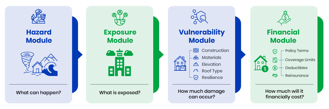
A Natural Catastrophe model functions as an integrated technology framework, relying on four core modules that run sequentially to convert environmental signals into clear financial insights:
-
Hazard Module:
Focuses entirely on the environmental threat, simulating the frequency, tracking, and severity of physical hazards across diverse geographies.
-
Exposure Module:
Serves as the database foundation, cataloging every insured property’s location, financial replacement value, and physical characteristics.
-
Vulnerability Module:
Blends engineering metrics with computer vision to calculate the exact percentage of physical destruction an asset will experience when exposed to a specific hazard intensity.
-
Financial Module:
Applies policy conditions, deductibles, retention limits, and reinsurance treaty rules to convert physical structural damage into net insurance claims and payout metrics.
Types of Catastrophe Models
Modern risk engineering uses a variety of model designs to evaluate environmental exposure, matching specific business goals with data availability and uncertainty levels:
-
Deterministic Models:
Run predefined, fixed scenarios to evaluate the absolute financial impact of specific worst-case catastrophes on a portfolio.
-
Probabilistic Models:
Generate large-scale, randomized scenario distributions to establish reliable long-term loss probabilities and premium baselines.
-
Stochastic Models:
Employ advanced statistical variations to map out uncertain natural behaviors and complex environmental combinations.
-
Scenario-Based Models:
Simulate specific hypothetical situations, such as unexpected multi-region storm interactions, to evaluate institutional disaster readiness.
-
Climate Simulation Models:
Analyze evolving environmental trends and long-term climate adjustments to project how future hazard patterns will shift over coming decades.
-
AI-Driven Catastrophe Models:
Leverage live cloud analytics, deep machine learning, and computer vision to deliver adaptive, highly contextual catastrophe risk intelligence.
Catastrophe Modelling Risks & Limitations
Even the most advanced risk frameworks must navigate core challenges driven by a changing environment and the complex, shifting nature of modern risks:
-
Escalating Natural Hazards:
The rapid increase in the size, frequency, and intensity of severe perils places an immense pressure on risk managers trying to build stable long-term prediction baselines.
-
Evolving Climate Dynamics:
Climate change creates non-stationary risk conditions where historical precedents no longer match modern realities, injecting substantial statistical uncertainty into legacy engines.
-
The Complexity of Secondary Perils:
Localized, rapid-onset secondary perils are naturally difficult to map out using traditional modeling tools. Sudden flash floods drop massive rainfall over narrow zones with minimal warning; severe convective storms create destructive hail tracks that challenge standard tracking grids; and rapid urban flooding strains local municipal drainage networks in highly crowded city settings.
-
Interconnected Man-Made Risks:
Modern natural disasters frequently collide with human infrastructure, leading to complex industrial accidents, long-term utility grid failures, and sweeping transport disruptions.
-
Cascading Systemic Vulnerabilities:
Risk teams must account for cascading disaster chains—where an initial hazard triggers a sequence of secondary crises, such as utility blackouts, regional supply chain halts, or widespread economic instability.
AI in Catastrophe Modelling
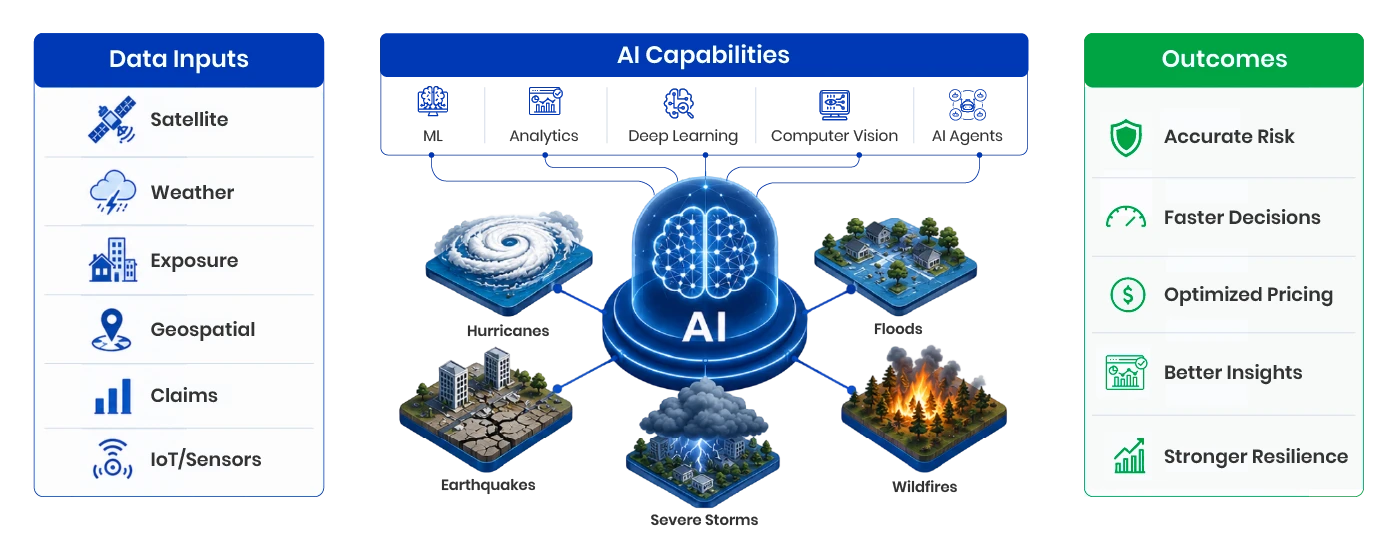
How AI Is Transforming NatCat Modelling
Artificial intelligence has fundamentally modernized the catastrophe risk workspace by providing rapid data processing, adaptive learning, and predictive precision:
-
Real-Time Risk Intelligence:
AI-powered engines process live weather streams, geospatial analytics, and IoT data loops to continuously monitor fluid environmental threats and portfolio exposures.
-
Improved Hazard Prediction:
Deep machine learning architectures evaluate complex environmental patterns to predict the onset and potential severity of floods, hurricanes, and wildfires with enhanced accuracy.
-
Advanced Vulnerability Analysis:
Advanced algorithms uncover subtle structural risk patterns hidden across thousands of properties, optimizing building vulnerability scores and damage projections.
-
Accelerated Scenario Simulation:
Cloud-native AI models evaluate complex probabilistic simulations significantly faster than legacy hardware, giving underwriting teams instant decision-making support.
-
Climate Intelligence Integration:
AI processes complex environmental variables to map future catastrophe threats across multi-year horizons, streamlining mid-to-long term strategic planning.
-
Automated Decision Ecosystems:
Automated systems link predictive analytics directly into daily operations, orchestrating automated pricing adjustments, live book monitoring, and claims response protocols.
Machine Learning Applications in Catastrophe Modelling
Machine learning bridges the gap between massive data volumes and clear operational choices:
-
Advanced Pattern Recognition:
Algorithms analyze vast repositories of historical claims, geospatial files, and climate datasets to uncover hidden risk correlations across separate underwriting lines.
-
Predictive Risk Forecasting:
Models predict hazard footprints and damage severities by processing environmental shifts in real time.
-
Real-Time Anomaly Detection:
Systems flag unexpected environmental variations and unusual threat signals that traditional statistical tools miss entirely.
Computer Vision & Satellite Analytics in Catastrophe Modelling
Computer vision turns unstructured satellite and aerial photography into clear, immediate risk data:
-
Satellite-Based Risk Monitoring:
High-resolution satellite loops offer continuous overhead monitoring of active wildfire boundaries, tracking coastal changes and localized flood boundaries.
-
Computer Vision for Damage Assessment:
Post-disaster vision models instantly evaluate aerial photographs to detect property-level damage, identify destroyed infrastructure, and accelerate loss estimation.
-
Automated Exposure Mapping:
Visual processing confirms exact structural parameters and detects building boundaries to verify property placement within designated high-risk zones.
-
Real-Time Disaster Tracking:
AI platforms analyze active imagery to map the progression of major hurricanes, river floods, and severe convective storms.
-
Accelerated Recovery Insights:
Rapid post-event image analysis allows carriers to validate claims instantly, map regional destruction zones, and allocate repair resources efficiently.
Agentic AI in Catastrophe Modelling
Agentic AI moves the technology beyond basic automation, utilizing intelligent reasoning systems to orchestrate multi-stage workflows without constant manual oversight:
-
Autonomous Simulation Orchestration:
Smart software agents can autonomously set up, run, and evaluate thousands of catastrophe simulations across varied geographic books and climate assumptions, cutting out slow configuration steps.
-
Contextual Reasoning Systems:
Advanced AI systems analyze complex data relationships—connecting micro-climate changes, building material limits, and financial contract rules to generate deep, contextual insights for risk officers.
-
End-to-End Workflow Automation:
Agents manage entire catastrophe processes from end to end, automatically pulling data inputs, mapping exposures, estimating loss margins, and preparing audit-ready compliance summaries.
-
Actionable Risk Narrative Generation:
Generative models distill dense computational analytics into plain-language risk summaries and strategic recommendations for underwriting and capital allocation executives.
-
Dynamic Environmental Adaptability:
Software agents actively monitor incoming environmental data streams, automatically adjusting underlying catastrophe assumptions the moment a disaster scenario changes on the ground.
Digital Twins in Catastrophe Modelling
Digital twins create real-time, highly detailed virtual replicas of properties, urban cities, and complex physical assets to help risk managers run lifelike disaster stress tests:
-
Live Structural Risk Simulation:
Digital duplicates continuously ingest weather data, geospatial changes, and structural sensor inputs to model exactly how a live hazard will impact physical assets across a specific city or region.
-
Infrastructure Resilience Analysis:
Risk management teams use virtual twins to evaluate how critical infrastructure elements—such as regional power grids, manufacturing hubs, and transportation junctions—will bend or break under extreme catastrophe stress.
-
Dynamic Exposure Monitoring:
Twins provide clear, live visibility into changing property conditions and environment dynamics, allowing teams to monitor risk shifts across global books of business.
-
Disaster Scenario Testing:
Organizations play out complex floods, wildfire spread, and cascading infrastructure collapses inside safe virtual testing environments to refine emergency response plans and loss control structures.
-
AI-Led Operational Support:
Combining digital twins with predictive analytics empowers insurers to optimize individual property underwriting, design target loss-mitigation solutions, and accelerate emergency claims responses.
Catastrophe Modelling Risks & Limitations
Modern catastrophe risk management relies on cloud-native software architectures that can ingest multi-format environmental data, process heavy financial algorithms, and connect directly with core enterprise applications.
Modern Catastrophe Modelling Architecture
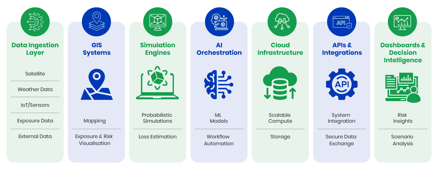
To support real-time data ingestion and high-speed processing, modern NatCat environments are built on a connected, multi-layered framework:
-
Data Ingestion Layer:
Constantly collects and processes massive datasets from live weather streams, overhead satellite images, IoT monitoring arrays, and enterprise claims logs.
-
GIS Systems & Platforms:
Geographic Information Systems map out exact exposure sites, visualize local peril boundaries, and support precise spatial risk evaluations.
-
Simulation & Modeling Engines:
Computational engines run advanced probabilistic iterations and deterministic scenarios to generate loss curves.
-
AI & ML Orchestration Layer:
Machine learning systems handle automated data validation, discover complex vulnerability patterns, and clean up multi-source records.
-
Cloud-Native Infrastructure:
Provides elastic, distributed computing power to process high-volume hazard simulations and handle massive data surges without slow downs.
-
Secure APIs & Integrations:
Connects modeling data into underwriting screens, claims workbenches, and third-party enterprise tools via fast, secured data connections.
-
Dashboards & Decision Intelligence:
Interactive front-end platforms display clear portfolio data, track regional accumulations, and surface actionable financial metrics for executive visibility.
Cloud-Native Catastrophe Platforms
Transitioning to cloud-native platforms gives insurers the elastic infrastructure needed to process massive environmental data loops and run high-volume scenario arrays simultaneously:
-
Elastic Computational Power:
Cloud environments allow risk teams to scale processing cores on demand, running thousands of complex probabilistic models over global portfolios in minutes.
-
Live Environmental Analytics:
Cloud platforms support continuous risk monitoring by seamlessly ingesting real-time weather, satellite, and GIS data streams.
-
Accelerated Model Deployment:
Technology teams can rapidly roll out, update, and fine-tune localized hazard modules without the restrictions of traditional on-premise servers.
-
Global Enterprise Accessibility:
Centralized cloud platforms ensure that distributed underwriting groups, global executives, and reinsurance partners can access uniform risk insights from any office.
API Integrations & Enterprise Systems
Ready-to-use APIs remove information silos, allowing catastrophe risk insights to flow automatically across every phase of the insurance lifecycle:
-
Real-Time Underwriting Sync:
APIs push modeling insights directly into underwriting workbenches, supporting automated risk triaging and fast premium pricing at the point of sale.
-
Claims Operations Readiness:
Direct links with claims management platforms help operations handle catastrophe events smoothly, optimize adjuster assignments, and fast-track valid payouts.
-
External Intelligence Connectivity:
Secured APIs allow platforms to pull updated hazard data from global weather loops, satellite providers, and open-source environmental databases.
-
Unified Enterprise Governance:
Catastrophe analytics sync seamlessly with corporate finance, risk management, and legal compliance software, supporting holistic resource planning and clean regulatory reporting.
Choosing the Right Catastrophe Modelling Platform
Finding the right technology platform requires careful alignment around structural performance, transparency, and data flexibility. A modern NatCat setup should act as a clear, integrated engine that balances four absolute priorities:
-
Scalability:
The architecture must be fully cloud-native, capable of handling massive environmental data pipelines and processing thousands of risk scenarios simultaneously across global books of business without performance loss.
-
Explainability:
As machine learning plays an increasing role in risk scoring, platforms must provide fully transparent, auditable risk calculations. Underwriters, regulators, and corporate stakeholders need clear insight into how specific loss estimates and vulnerability scores are generated.
-
Interoperability:
The solution must fit seamlessly into your existing corporate ecosystem. It needs ready-to-use APIs and robust data bridges that instantly feed insights into your underwriting workbenches, claims workflows, GIS tracking software, and enterprise risk management applications.
-
AI Readiness:
Look for an environment built to support advanced machine learning, predictive analytics, computer vision, and autonomous agentic workflows out of the box, ensuring your risk operations stay ahead of a rapidly changing climate.
When evaluating these criteria, forward-looking insurers frequently seek digital engineering partners that combine advanced AI research with mature cloud architecture capabilities. Companies like Quantiphi are actively helping insurance carriers modernize their risk environments by deploying tailored, cloud-native catastrophe analytics, advanced geospatial engines, and robust document intelligence solutions that transform complex climate variables into accurate operational foresight.
Benefits of Catastrophe Modelling
Implementing a modern, AI-powered catastrophe modeling framework provides clear strategic value across the entire enterprise, protecting long-term financial health while optimizing daily insurance processes:
-
Precision Underwriting:
Ingesting property-level hazard data lets underwriters move past basic paperwork to evaluate risks accurately, optimize policy terms, and ensure high portfolio quality.
-
Fair, Accurate Pricing:
Aligning premium calculations directly with granular peril statistics allows actuarial teams to implement risk-based pricing that reflects real-world environmental exposure.
-
Optimized Reinsurance Spend:
Granular loss curves allow risk managers to map out exactly how much exposure to hold and how much to transfer, maximizing the cost-efficiency of global reinsurance placements.
-
High Capital Efficiency:
Quantifying extreme tail-risk scenarios helps executive teams allocate capital reserves strategically, protecting solvency while maximizing capital utility.
-
Seamless Regulatory Compliance:
Automated reporting and clear analytics simplify compliance with modern climate disclosure mandates, stress-testing audits, and solvency reviews.
-
Long-Term Climate Resilience:
Leveraging predictive risk data allows companies to strengthen their operational safety margins, prepare for weather events, and adapt to long-term climate adjustments confidently.
Real-World Use Cases of Catastrophe Modelling
Catastrophe modelling is transforming operational approaches across a diverse range of modern industries and public operations:
-
Insurance Portfolio Risk Management:
Insurance carriers utilize models to reveal hidden exposure concentrations across their books of business, allowing them to balance regional allocations and set accurate policy terms.
-
Reinsurance Structuring:
Reinsurers rely on probabilistic engines to evaluate macro-level disaster exposures, balance cross-border risk pools, and protect institutional capital reserves against severe tail events.
-
Government Disaster Planning:
Public sector agencies leverage modeling platforms to run realistic evacuation tests, design disaster readiness plans, and optimize emergency response resources before catastrophic events occur.
-
Critical Infrastructure Protection:
Energy providers, logistics networks, and transport operators utilize digital risk twins to evaluate the physical resilience of utility grids, airports, and shipping ports against severe weather.
-
Climate Risk & ESG Planning:
Modern enterprises implement advanced catastrophe models to prepare audit-ready ESG disclosures, fulfill mandatory climate risk reporting, and construct long-term sustainability plans.
-
Supply Chain De-Risking:
Supply chain operations use peril simulations to flag geographical choke points, locate vulnerable supplier clusters, and map out alternative distribution networks to preserve business continuity.
-
Banking & Financial Governance:
Banking groups integrate catastrophe intelligence into their credit models to evaluate loan exposure on climate-sensitive real estate, execute portfolio stress tests, and maintain balanced governance across asset classes.
ROI of Catastrophe Modelling
Investing in a modern catastrophe framework delivers clear financial rewards and operational advantages, helping companies protect their margins while accelerating business growth:
Financial Benefits
-
Premium Optimization:
Risk-based premium alignment directly boosts core underwriting profitability.
-
Minimized Volatility:
Proactive risk matching prevents unexpected, heavy losses from draining seasonal profits.
-
Reinsurance Cost Control:
Precise coverage metrics eliminate duplicate coverage expenses and optimize risk transfer budgets.
-
Strategic Capital Reserves:
Accurate loss curve forecasting avoids over-funding restricted reserve accounts, freeing up capital for active market investments.
Operational Benefits
-
Accelerated Underwriting:
Real-time data streams provide immediate risk profiles, helping underwriters quote and bind business faster.
-
Enhanced Surge Readiness:
Predictive insights allow claims teams to deploy resources ahead of storm impacts, ensuring fast, organized customer support.
-
Granular Risk Visibility:
Live dashboards provide data-led visibility across multiple lines of business and regions from a single screen.
-
Informed Corporate Planning:
Risk analytics provide corporate leadership with a data-driven baseline for long-term real estate investments and asset acquisitions.
Key Risk Reduction Metrics
-
Probable Maximum Loss (PML):
Keeps extreme, low-frequency event exposures within strictly defined corporate risk limits.
-
Average Annual Loss (AAL):
Standardizes pricing models to ensure premiums consistently cover long-term peril baselines.
-
Exposure Concentration Index:
Flags when property accumulations in a single flood zone or wildfire path risk heavy aggregation losses.
-
Portfolio Diversification Score:
Tracks risk distribution metrics to confirm health across distinct geographies and hazard types.
Long-Term Resilience Value
-
Proactive Climate Adaptation:
Shifting from old historical records to live, predictive data empowers companies to navigate changing weather realities confidently.
-
Rock-Solid Business Continuity:
Early warning alerts and infrastructure twin testings help enterprises minimize commercial downtimes during regional crises.
-
Audit-Ready ESG Position:
Seamless data synchronization generates verified disclosures that build trust with global investors and regulatory auditors.
-
Sustainable Operations Framework:
Building daily underwriting and investment choices around deep catastrophe intelligence ensures profitable growth for decades to come.
How Quantiphi Enhances Catastrophe Modelling
As modern climate disruptions grow more complex and interconnected, relying on manual data reviews and legacy spreadsheets exposes an organization to severe margin leakage. Insurers need specialized technology environments that can transform massive environmental datasets into immediate operational decisions.
Quantiphi helps global insurers modernize their risk ecosystems by deploying cloud-native catastrophe intelligence solutions powered by advanced AI and geospatial analytics:
| Capability | Core Technology | Operational Business Value |
|---|---|---|
| AI-Powered Climate Intelligence | Next-Gen AI Weather Models | Delivers highly accurate micro-scale weather predictions and advanced climate forecasting. |
| Real-Time Geospatial Analytics | Computer Vision & Image Processing | Extracts asset characteristics from high-resolution satellite imagery to improve exposure mapping. |
| Enterprise AI Integration | Dociphi & Core Integrations | Connects risk intelligence into underwriting platforms, achieving >90% data extraction accuracy. |
| Operational & Financial Outcomes | Automated Workflows | Drives strategic pricing, leading to a 30% lift in underwriting accuracy and a 20% claims payout reduction. |
By deploying specialized automation platforms like Dociphi for intelligent document processing, Quantiphi enables insurance organizations to eliminate the manual “stare-and-compare” bottlenecks of portfolio monitoring. The cloud-agnostic architectures integrate smoothly into existing underwriting workbenches via secure APIs, giving risk teams the actionable, real-time insights required to build long-term climate resilience and maintain a strong competitive edge
Quantiphi enhances catastrophe (CAT) modelling by integrating next-generation AI and advanced simulation technologies to predict, price, and mitigate climate-related risks. By leveraging partnerships with leaders like NVIDIA, Quantiphi transforms traditional risk assessment into a proactive, data-driven discipline.
Key enhancements include:
- AI-Powered Predictive Accuracy: Quantiphi utilizes cutting-edge AI weather models to analyze vast datasets, enabling more accurate and detailed short-term, long-term, and micro-scale forecasts than traditional methods.
- Digital Twin Simulations: Quantiphi employs Digital Twin technology to offer unparalleled precision in modelling disaster extent and simulating climate trends.
- Advanced Image & Video Analytics: The use of satellite imagery combined with AI-driven computer vision allows for real-time damage assessment, identifying high-impact zones and detecting building boundaries to improve loss estimation accuracy.
- Dynamic Underwriting and Pricing: By integrating climate risk insights directly into underwriting, Quantiphi enables adaptive pricing models and dynamic NatCat holds that account for evolving environmental variability.
- Proactive Loss Mitigation: AI-driven early warning systems and hazard monitoring help insurers and communities anticipate storms, allowing for proactive risk and exposure control measures and resource prioritization.
- Operational Efficiency: Quantiphi’s solutions have demonstrated measurable business value, including a 30% improvement in underwriting accuracy, a 20% reduction in claims payouts, and 50% faster response times in disaster recovery.
- Compliance and Reporting: AI streamlines regulatory reporting and climate risk and exposure disclosures, ensuring insurers remain compliant with evolving environmental mandates.
The evolution of catastrophe modelling from static historical analysis to AI-driven, real-time simulation represents a paradigm shift in how the insurance industry handles climate risk. By leveraging advanced technologies like Digital Twins and agentic AI, organizations can now predict disaster impacts with unparalleled accuracy, allowing them to protect their margins while building greater resilience for the communities they serve.
Future of Catastrophe Modelling
The future of catastrophe analytics belongs to organizations that treat environmental risk as a dynamic, live variable rather than a static historical metric. The coming era of risk management will see a shift toward completely autonomous, agentic AI systems that monitor real-time satellite imaging, update property vulnerability models, and adjust portfolio risk pricing with minimal manual intervention.
At the same time, catastrophe modeling will expand past the boundaries of traditional insurance, becoming a foundational tool for urban municipal planning, global supply chain configuration, corporate ESG compliance, and long-term asset management. Organizations that proactively adopt cloud-native AI platforms and robust digital twin technologies will be uniquely positioned to protect their financial margins, satisfy modern regulatory bodies, and deliver stable financial protection to the communities they serve in an increasingly volatile world.